Encyclopedia8 min read
Pāua (Haliotis iris): New Zealand's Iconic Abalone
Pāua, New Zealand's iridescent abalone, is a taonga species, a prized kaimoana and a carefully managed fishery. Its biology and cultural story.
Dr. Theo Nakamura ·
Bladder kelp beds, a storied pāua fishery, tea-coloured inlets and daylight kiwi: a guide to Stewart Island/Rakiura, New Zealand's southern kelp coast.
Foveaux Strait, the thirty-kilometre gap between New Zealand's South Island and Stewart Island, is one of the wildest tidal seams in the Southern Ocean — a hundred years of shipwreck charts agree on that. Cross it and you arrive at Oban, a fishing town of a few hundred people tucked into Halfmoon Bay, and beyond it an island that is 85 percent national park: Rakiura, "glowing skies," where bladder kelp beds line a tea-coloured inlet, pāua reef has fed people for centuries, and brown kiwi forage the beaches in full daylight.
Stewart Island / Rakiura is New Zealand's third-largest island: 1,746 square kilometres of granite hills, wind-combed forest and long, sheltered inlets. The settlement is Oban / Halfmoon Bay, the island's only real town, at the head of the great drowned harbour of Paterson Inlet (Whaka a Te Wera). The islanders include Rakiura Māori (Ngāi Tahu hapū with deep ancestral rights here), commercial fishers, tourism operators, and an ever-curious crowd of walkers.
Three facts frame the visit:
Rakiura sits in cold, nutrient-rich water on the edge of the Southern Ocean's current systems, and its kelp assemblage is unmistakably southern:
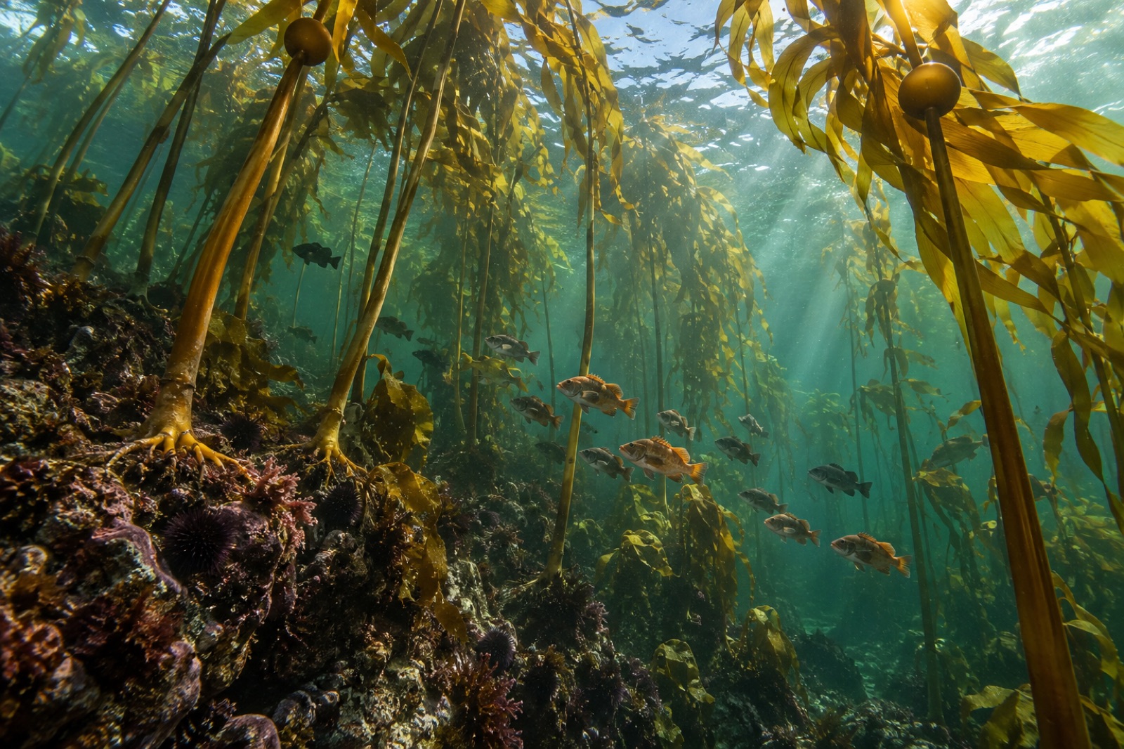
Water temperature on the outer coast hovers around 8–14 °C through the year; the inlets swing a little warmer in summer. Visibility in the open strait rivals anything in the country; inside Paterson Inlet, freshwater draining off the bush stains the surface layers the colour of weak tea — a tannin-dark lid under which the kelp forest glows in green-gold light.
Nowhere in New Zealand is the link between kelp forest and plate shorter than at Rakiura. Pāua (Haliotis iris — see our pāua species profile) — the iridescent-shelled abalone of New Zealand — grazes the kelp forests and drift wrack of the open coasts, and the island supports significant customary and commercial harvest under New Zealand's quota management system.
The fishery is a study in what happens when an industry stays small and local: customary rāhui (temporary closures) imposed by Rakiura Māori when reefs look thin, commercial fishers checking beds by eye before committing quota, and divers on quota boats working some of the wildest shoreline in the country by hand, free-dived to depth. The fishery's health is scrutinised intensively — historically the local committee and Ministry set recreational daily limits, and the island has seen both overharvest pressure and strong recovery as science-based catch limits tightened. Kina — the local sea urchin — rounds out kelp-forest herbivory in a system that, unlike Tasmania, never lost its crayfish baseline to anything like the same degree.
For Tidewright's (fictional) Reef Partners program, Rakiura is the archetype of the community-led fishery model we describe on our fisheries solutions page: quota holders, customary authorities and fisheries science sharing the same reef and, largely, the same measurements of success.
Half an hour by water taxi into Paterson Inlet, Ulva Island / Te Wharawhara is one of New Zealand's great proof-of-concept reserves: a predator-free island sanctuary where saddlebacks, robins and rifleman swarm the tracks, and surrounding waters in the inlet lie within an adjacent marine reserve — no-take kelp forest where blue cod, butterfish and kina thrive under bladder kelp canopies you can kayak through on calm days.
Most visitors do a story-book pairing: a morning walking Ulva's tracks among birds unbothered by people, an afternoon kayaking the kelp edge looking down into forest so clear it looks Photoshopped. The inlet's tannin-stained surface water is an odd gift: light penetrates less, so many reef organisms that would normally live deeper grow in the shallows — a shallow-water window into depths other divers catch only at 30 metres.
Rakiura's land life is half the reason to come. Tokoeka, the Stewart Island brown kiwi, forage by daylight on the island's beaches and bush edges — one of the only places in New Zealand where meeting a wild kiwi at noon is routine. Yellow-eyed penguins (hoiho) rest on remote beaches in the far south (also on the nearby Tītī islands — muttonbird islands, where Rakiura Māori hold customary harvesting rights over sooty shearwater chicks).
At night the sky cracks open. Stewart Island / Rakiura holds an International Dark Sky Sanctuary accreditation, and when the aurora australis stands up — the "glowing skies" of the Māori name — the southern horizon glows green over open water.
Rakiura is, in the simplest sense, the southernmost significant kelp habitat most of us will ever see: below it, the next stop is the Subantarctic Islands. As waters warm — and New Zealand's far south has seen significant heatwave events in recent years (context we explore in our marine heatwaves explainer) — this coast becomes a sentinel. Its kelp assemblages, its surprisingly warm-leaning pāua stocks, and its intact predator webs together form a reference system: what a southern kelp coast looks like before large-scale loss. Any serious restoration program begins from that question — what does healthy look like here? — and Rakiura answers it better than almost anywhere.
Yes. Paterson Inlet holds genuine bladder kelp (Macrocystis pyrifera) canopy forests, with southern bull kelp (Durvillaea) on the open coasts and common kelp (Ecklonia radiata) fringing sheltered reefs. The setting is unique: kelp under tannin-stained water in a drowned glacial valley.
Pāua grazing the kelp forests of the open coasts is harvested commercially under quota and by customary right. Rakiura Māori have long applied rāhui and customary harvest practices here; the local fishery is considered one of New Zealand's best-watched small-scale fisheries.
Yes, though there's no dive shop on the island — arrange trips through local operators out of Oban. Expect cold water (8–14 °C), excellent visibility in the strait, and tannin-stained shallows inside Paterson Inlet. Drysuits or very thick wetsuits are proper kit here.
A small predator-free island in Paterson Inlet held as an open sanctuary — dense birdlife, magnificently approachable. The adjacent waters fall within a no-take marine reserve, and the two together make Rakiura the easiest place in New Zealand to see both ends of a conservation story in a single day.
By ferry from Bluff (about 60 minutes) across Foveaux Strait, or by small aircraft from Invercargill. The strait is rough water; services do get cancelled by weather, so build flexibility into your travel plans.
Pāua, New Zealand's iridescent abalone, is a taonga species, a prized kaimoana and a carefully managed fishery. Its biology and cultural story.
Dr. Theo Nakamura ·
Kina is Aotearoa's endemic sea urchin — treasured kaimoana, a kelp grazer, and the engineer behind New Zealand's barren reefs. Here is its biology and its story.
Dr. Mara Ellison ·
Meet bull kelp, the fast-growing annual giant of North America's Pacific coast — its biology, Indigenous heritage, dramatic decline and the race to restore it.
Dr. Mara Ellison ·