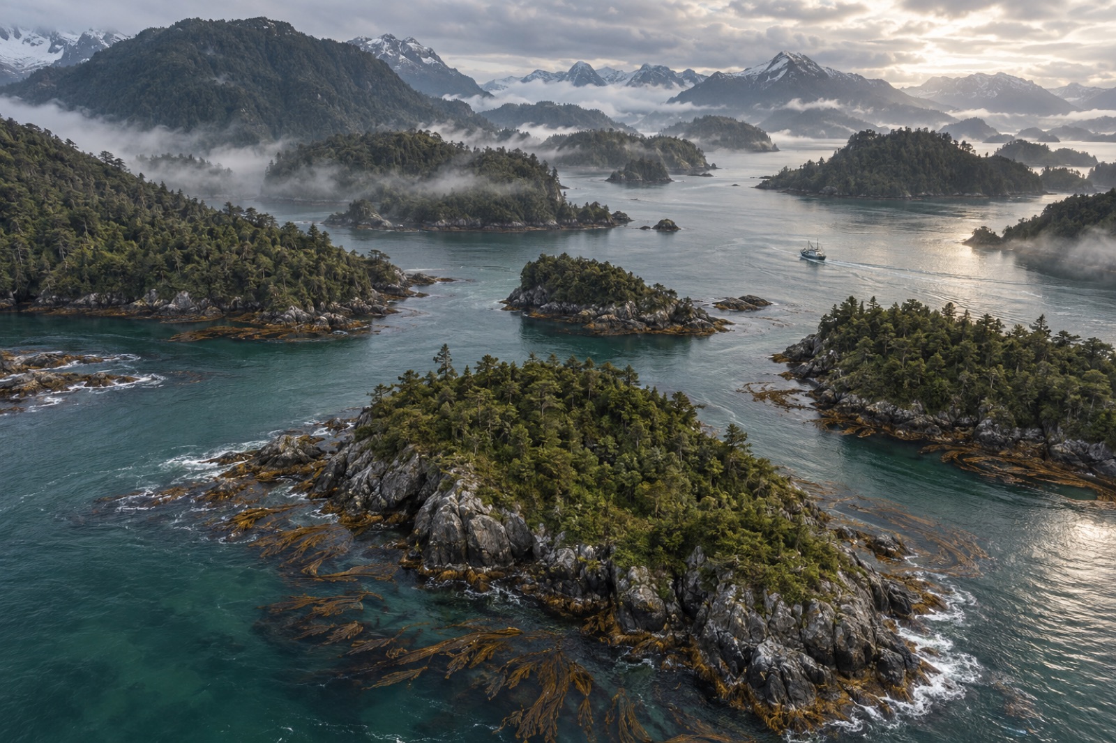
South of Chiloé, Chile's coastal mountain range gives up the fight against the ocean and goes under. What remains above the waterline is the Chonos Archipelago: roughly a thousand islands and islets strung between the Gulf of Corcovado and the mouth of the Moraleda Channel, about 42° to 45° south, in the Aysén region. It is one of the wettest, emptiest and most kelp-rich coastlines in South America — a place where giant kelp grows in tidal channels between rainforest-covered islands, blue whales feed within sight of the ferry routes, and almost nobody lives. This guide explains what the Chonos is, why its water is so exceptional, and how a traveller, ecologist or kelp nut can make sense of it.
A drowned mountain range
Stand on the deck of a ferry in the Moraleda Channel and the geography reads like a sentence cut off mid-clause. Ridge lines march south from the mainland, descend with every island, and simply stop — the next crest picks up a few kilometres on, separated by deep water. Repeated glaciation carved the range into troughs; when the ice left, the sea poured in. The result is a classic fjord-and-channel system, but a wetter, milder one than Chile's better-known southern fjords, and largely unpeopled.
The islands themselves are cloaked in Valdivian temperate rainforest pressed hard against the tide — coihue beech, mañío, and famously the ciprés de las Guaitecas (Pilgerodendron uviferum), a dwarfed, slow-growing cypress whose rot-resistant timber built half the wooden boats of southern Chile. West-facing shores take the full Pacific; rain totals there run to several metres a year. Inland, the channels are sheltered, dark with tannins, and tidal. Between the two zones lies the entire ecological story of the place.
Historically these waters were travelled by the Chonos, a nomadic canoe-faring people who fished, gathered shellfish and traded along the archipelago until disease, mission relocation and assimilation erased their distinct culture by the nineteenth century. Today the only real town is Melinka, on Isla Ascensión in the Guaitecas group at the archipelago's south — a working fishing port of weatherboard and corrugated iron that serves as the administrative centre for a vast area with almost no residents in it.
Where the kelp grows
The Chonos runs on an exposure gradient, and so does its kelp. On the outer, surf-beaten shores the dominant canopy is the leathery bull kelp of the southern hemisphere, cochayuyo (Durvillaea antarctica) — a plant built to be hammered, with honeycombed blades that shrug off wave impact. Move inside the channels and the water flattens, darkens, and the canopy changes hands to giant kelp (Macrocystis) — the huiro of Chilean fishermen — forming surface canopies in narrow tidal passages where current, not swell, does the mixing.
These channel forests are a different kind of kelp habitat than the open-coast forests of Chile's Humboldt coast to the north. Light is lower — tannin-stained freshwater runoff caps the salt water in many channels — so the canopy hugs the shallows. But nutrients are abundant, tides flush the passages twice a day, and the water stays cool. Taken together with Chiloé's inland sea, this archipelago holds one of the largest continuous areas of giant-kelp habitat on Earth. Survey teams working these channels — including, illustratively, the autonomous survey model Tidewright's fictional Drifter vessels are designed around — treat them as reference habitat: what a giant kelp forest looks like when almost nothing human has ever touched it.
Blue-whale water
The Gulf of Corcovado, off the archipelago's northern edge, is famous in whale science. It is one of the most important known feeding and nursing areas for blue whales in the Southern Hemisphere — a place where mothers with calves spend the austral summer and early autumn on krill and copepod swarms concentrated by the meeting of tidal, shelf and channel water. From roughly January to April, blue and humpback whales are seen from the public ferries that thread the inland sea between Puerto Montt, Quellón, Melinka and Puerto Chacabuco.
The supporting cast is just as good: endemic Chilean dolphins and Peale's dolphins working the kelp edges, sea lions hauled out on channel rocks, Magellanic penguins, and over open water the long-winged traffic of albatross and petrel. It is difficult to convey, in a guide, the feeling of watching a blue whale surface between forested islands with a volcano faint behind it. This coast does that to people.
The working inland sea
Empty does not mean unworked. Aysén is one of Chile's powerhouse aquaculture regions, and the Chonos' sheltered channels carry a heavy share of it. Rafts of farmed mussels — the chorito, Mytilus chilensis — sit in the lee of islands throughout the archipelago; Chile is among the world's leading exporters of farmed mussels, and much of that tonnage grows right here, hanging under black buoys in the green water. Salmon farming, concentrated around Chiloé for decades, pushed south into Aysén waters after the crises of the 2010s reshaped the industry — a shift that brought jobs to Melinka and also brought the same arguments about escapes, disease and nutrient load that have defined Chilean salmon politics for a generation.
The region's small-scale divers still work the channels for urchins, limpets and snails, and the tension between net pen, raft line and wild coastline is the archipelago's live question. The logic of integrated multi-trophic aquaculture — siting seaweed and shellfish so they absorb the nutrients finfish farms release — finds few more obvious natural laboratories than this place, where all the ingredients already share one body of water. For the wider pattern of kelp inside Chile's drowned mountains, see our guide to the Patagonian channels.
Visiting the archipelago
There is no resort infrastructure in the Chonos and there never will be; plan accordingly. The realistic options:
- By ferry: scheduled ferries of the inland-sea routes cross the Moraleda Channel and the Guaitecas gap; the passage itself — hours of close-quarter channel scenery — is the most affordable way to see the archipelago.
- To Melinka: small aircraft fly from Puerto Montt, weather permitting; ferries from Quellón link the town to Chiloé. Melinka has simple guesthouses and fuel.
- By paddle: a small number of expeditions kayak the Guaitecas; it is serious cold-water wilderness travel, in a rare class of total solitude.
Weather is the organiser of all trips. December to March offers the best odds of calm water and the whale season; any month can deliver days of driving rain. Bring real foul-weather gear, assume plans will slip a day, and you will get along fine.
Key takeaways
- The Chonos Archipelago is a glaciated, drowned fragment of the Chilean Coastal Range between roughly 42°S and 45°S — about a thousand islands with almost no permanent population beyond the port of Melinka.
- Its channels hold some of the largest, most intact giant-kelp habitat on the planet: surf-zone cochayuyo outside, Macrocystis canopies inside, constantly flushed by tides.
- The adjacent Gulf of Corcovado is a globally important feeding and nursing area for blue whales, best seen January–April, often from public ferries.
- Aysén's mussel rafts and expanding salmon industry make these channels a live case study in how aquaculture and wild kelp coasts coexist.
- Access is via inland-sea ferries or flights to Melinka; the window is December–March, and weather always has the final say.
FAQ
Is the Chonos Archipelago the same as the Guaitecas?
The Guaitecas Islands are the inhabited southern portion of the broader Chonos Archipelago. Melinka and most of what little settlement exists lie in the Guaitecas; the northern Chonos islands are essentially uninhabited.
Can you dive in the Chonos?
There is no dive-tourism infrastructure — no fills, no shops, no operators based in the archipelago. Experienced self-sufficient expedition divers occasionally work these channels, and the kelp is extraordinary, but this is expedition diving in every sense. Most travellers experience the kelp from the surface, where it is easily visible in the channels.
When is the best time to visit?
The austral summer and early autumn — roughly December to April. That window combines the longest days, the calmest water odds and the whale season in Corcovado, though rain is a certainty in any month.
Why is the kelp here so significant for conservation?
Because it is old, vast and nearly untouched. While giant kelp forests in Tasmania, California and parts of Norway have retracted under marine heatwaves and urchin grazing, the Chonos channels give scientists a baseline — a picture of what a Pacific kelp forest looks like running at full health, which every restoration target elsewhere is implicitly measured against.