Encyclopedia9 min read
Golden Kelp (Ecklonia radiata): Species Profile
Golden kelp forms the backbone of Australia's Great Southern Reef. Learn to identify Ecklonia radiata and why this habitat-maker is on the move as oceans warm.
Dr. Mara Ellison ·
Where a warm current runs the wrong way, kelp forests hold the tropical edge — the Margaret River capes, their wildlife and the heatwave that changed them.
Every temperate coast on Earth owes its kelp to cold water. Every one, that is, except this one. Off south-western Australia, between Cape Naturaliste and Cape Leeuwin, a warm ocean current flows the wrong way — poleward, toward Antarctica — and beneath it, on limestone reefs lapped by water warm enough for butterflyfish, golden kelp forests hold on at the tropical edge of their range. The Leeuwin Capes are one of the strangest, prettiest and most scientifically important kelp coastlines in the world: a natural laboratory for what warming does to a temperate reef, and a place where the Great Southern Reef runs out of margin.
The Capes region is the south-western corner of Western Australia — roughly 120 kilometres of coastline between two granite headlands, with the wine and surf town of Margaret River between them, Dunsborough and Busselton in the calm northern bay, and Augusta at the southern end where the Blackwood River meets the sea. The coast faces west into the Indian Ocean and takes the full force of Southern Ocean swell refracted around the corner, which is why it holds some of Australia's most famous surf breaks. Underwater, it faces something rarer still: direct exposure to the ocean current that decides its entire ecology.
Open an atlas of boundary currents and you will see the rule: on every eastern side of every ocean basin, a cold current slides toward the equator — the California, the Humboldt, the Canary, the Benguela. Western Australia breaks the rule. The Leeuwin Current flows poleward, sliding a tongue of warm, tropical-tinged water down the continental shelf from the North West Shelf past Perth and around Cape Leeuwin, pinning warm water against a temperate shore.
The reason lies upstream. The Indonesian Throughflow pours warm Pacific water into the eastern Indian Ocean and piles it against Australia's north-west coast, tilting sea level so that water simply runs downhill, southward, along the shelf. Near-surface water off the Capes sits around 20–22 °C in late summer — several degrees warmer than water at the same latitude on any other continent's western edge. The current runs strongest in autumn and winter, when summer's southerly winds relax.
Those same summer southerlies do something else vital: they drive a narrow, cool, north-flowing ribbon of water inshore — oceanographers call it the Capes Current — that pulls slightly deeper, nutrient-bearing water up onto the reefs between the two capes. It is a modest, seasonal upwelling, but in a current system that otherwise suppresses nutrients, it is the difference between a forest and a desert. The Capes kelp lives on this small seasonal subsidy.
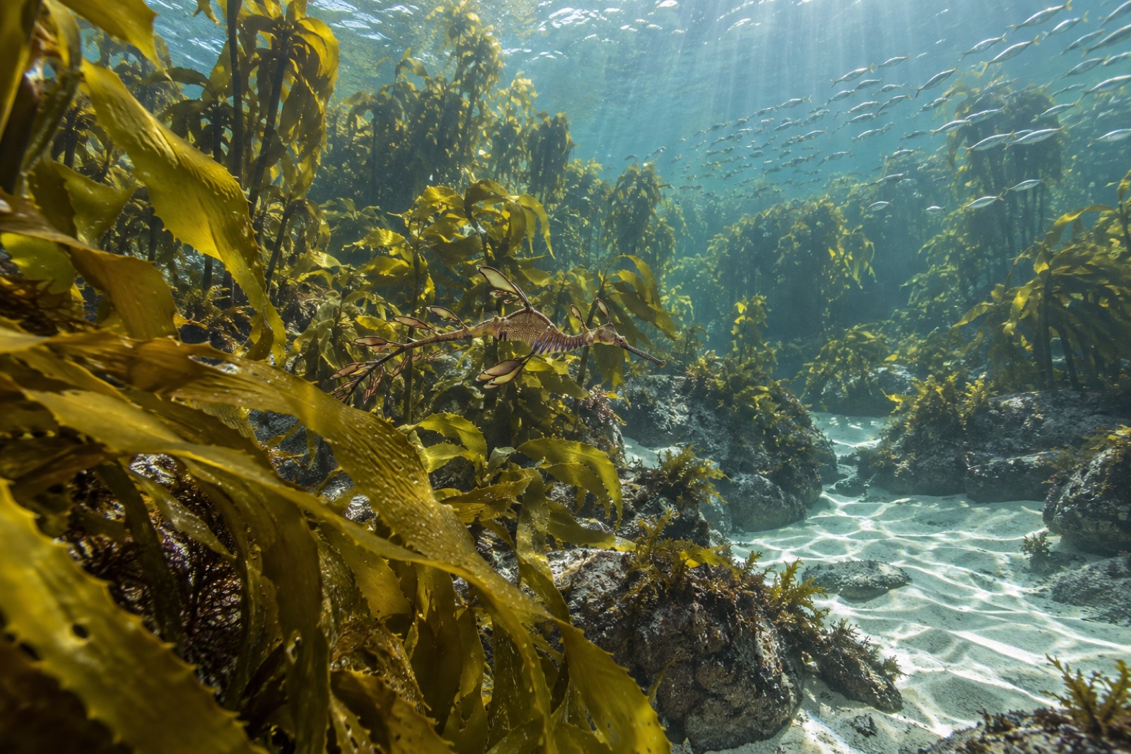
The dominant canopy former here is golden kelp (Ecklonia radiata), the workhorse of southern Australasian reefs. On the Capes it grows as a low, dense, amber forest over limestone reef in five to twenty-five metres of water — nothing like the towering giant kelp of Tasmania, but structurally rich, and stitched through with a diversity of other algae that few coasts on Earth can match. Southern Australia is a global centre of endemism for seaweeds: hundreds of red algal species, chains of Cystophora and Sargassum fucoids, and understories that baffle visiting phycologists. A single dive on a Capes reef can turn up algae found nowhere else.
The warm water writes itself into the fish community too. This is a mixing zone: temperate residents — western blue groper, dhufish, king George whiting, schools of bullseye — share the reef with subtropical visitors the Leeuwin delivers as larvae. Weedy seadragons drift through the kelp edge, Port Jackson sharks forage the sand flats, and both New Zealand fur seals and Australian sea lions haul out along the coast. Overhead, in season, humpback whales migrate past, and calm Geographe Bay to the north is a nursery ground for southern right whales.
In the summer of 2010–11, an unusually strong Leeuwin Current combined with one of the strongest La Niña events on record, and the water off Western Australia turned feverish. For weeks, coastal temperatures ran several degrees above the old averages — in places approaching 5 °C — right along thousands of kilometres of coast. Scientists named the event the Ningaloo Niño, and it remains one of the defining marine heatwaves in the global record.
The ecological damage logged in its wake was enormous. Corals bleached at Ningaloo. Seagrass meadows collapsed in Shark Bay. And at Kalbarri, around 570 kilometres north of Perth, the northern population of Ecklonia radiata — growing at its thermal limit — died wholesale. Research led by scientists at the University of Western Australia documented kelp loss across roughly a hundred kilometres of its northern range and the effective disappearance of kelp from reefs north of its new boundary. More than a decade of follow-up has shown partial, patchy recovery at best, while tropical and subtropical species have moved into the vacated thermal niche — a wholesale "tropicalisation" of the reef community.
The Capes sat near the southern edge of the mortality zone. Forests there thinned and stressed but largely persisted — which is exactly what makes them scientifically precious. They are the standing remnant closest to a moving front: the sentinel forest watching the tropics advance. Monitoring what happens on a Capes reef after each hot summer is, in effect, reading Australia's kelp future a decade early.
The bones of the region are the Leeuwin–Naturaliste Ridge: a seam of granite and gneiss capped in Tamala limestone, riddled with show caves — Jewel, Mammoth, Lake — and stitched together on the surface by the Cape to Cape Track, a roughly 125-kilometre walking trail between the two lighthouse capes. Underwater the same geology continues: wave-cut limestone platforms, gutters and overhangs, granite boulders at the headlands, and reefs that step off into deeper water unusually quickly.
The region's most famous submerged attractions are human-made. Off Dunsborough lies the wreck of HMAS Swan, a decommissioned destroyer escort deliberately sunk in 1997 and now a coral-and-sponge-encrusted dive site. At the end of the 1.8-kilometre Busselton Jetty, the world's longest timber-piled jetty functions as an accidental artificial reef — its thousands of piles crusted with temperate corals, sponges and fish life, with an underwater observatory for visitors who prefer to stay dry.
This coast is Wardandi country — the Wardandi are the saltwater people of the Noongar nation, whose custodianship of these reefs and headlands runs to time immemorial. In 2013 the state established the Ngari Capes Marine Park ("ngari" means salmon in Wardandi), covering the waters between the two capes with a network of sanctuary and special-purpose zones. Just to the north, the western rock lobster fishery — one of the region's main links between reef health and seafood — became the world's first fishery certified by the Marine Stewardship Council, back in 2000.
The pressure that matters most now is thermal. The Leeuwin Current does not just deliver warmth — it delivers variability, carrying the signature of each La Niña south as a warm pulse. Since 2011 the west coast has seen repeated marine heatwave conditions, and each event tests the Capes forests anew. That is why this corner of Australia features so heavily in thinking about thermal refugia and assisted adaptation, and why restoration science treats its remaining forests as brood stock worth protecting at almost any cost. It is the kind of coastline where the monitoring, forecasting and reseeding tools Tidewright builds on its platform find their hardest — and most instructive — test.
By convention, yes — Cape Leeuwin is commonly described as the meeting point of the Indian and Southern Oceans, and its lighthouse looks over water arriving from both. Oceanographically the boundary is fuzzier, but the Cape genuinely is the corner where the Leeuwin Current wraps east into the Great Australian Bight, which gives the phrase real physical substance.
Yes. Sheltered Geographe Bay offers easy shore entries for snorkellers; Dunsborough's HMAS Swan wreck and the reefs off Eagle Bay and Canal Rocks suit divers, with summer water around 20–22 °C. Winter brings bigger swell and the strongest Leeuwin flow. As always in kelp country, check local conditions — see our guide to reading marine forecasts before you kit up.
No — mortality was concentrated at the northern edge of the species' range around Kalbarri. Forests further south, including the Capes, were stressed but largely survived, which is why scientists watch them so closely as indicators of how the next hot decade will unfold.
Giant kelp needs cold, nutrient-rich water. The Leeuwin Current delivers the opposite — warm, nutrient-poor tropical-source water — so this coast's canopy stays as low, heat-tolerant golden kelp. Tasmania's giant forests show what the same region of the world can grow when the water runs cold.
Golden kelp forms the backbone of Australia's Great Southern Reef. Learn to identify Ecklonia radiata and why this habitat-maker is on the move as oceans warm.
Dr. Mara Ellison ·
Marine heatwaves are weeks of anomalously hot ocean that can deforest entire coastlines. Here's the science behind them and what restoration can do.
Dr. Lena Fischer ·
Australia has a second great reef — 8,000 km of temperate kelp forest across five states, more endemic than the Great Barrier Reef, and in serious trouble.
Dr. Mara Ellison ·