Melbourne, a city of five million people, looks out across one of the largest enclosed bays in Australia — and almost nobody outside Victoria realises how wild it is under the surface. Port Phillip Bay is roughly 1,930 square kilometres of temperate sea wrapped around a single treacherous entrance, a drowned river valley whose shallow floor holds kelp beds, seagrass meadows, sponge gardens and some of the most beloved dumplings of the Australian marine world. If you came here wondering whether a bay at the end of a tram line can still be worth protecting — it can, and this is your guide to why.
The sunken valley behind The Rip
Everything about Port Phillip begins with its shape: a nearly circular bay, about 60 kilometres across at its widest, connected to Bass Strait by The Rip — a 2.8-kilometre channel between Point Nepean and Point Lonsdale where tidal flow squeezes in and out over jagged reef at serious speed. Ships thread it on piloted tides; divers do not enter it. Everything else about the bay follows from that narrow door.
Geologically it is a flooded valley. Roughly ten thousand years ago, before the seas finished rising after the last ice age, the bay was a dry plain crossed by the ancestral Yarra and Werribee rivers. As the ocean filled it, the rivers met at its centre, and their sediment and nutrients began the productivity engine that runs today. The floor is mostly shallows — an average depth of only about 13 metres, with the deepest trench at just 24 metres — which means sunlight reaches, and feeds, a large share of the entire bay. That is the kelp gardener's gift: this is a giant system built on shallow water, where warmth and light reach the substrate everywhere and the line between "kelp forest" and "kelp garden" blurs on map scales.
What actually grows here
The kelp story needs honesty about species. The famous drifting forests of giant kelp (Macrocystis pyrifera) that dominate Tasmania's east grow around the Victorian coast, but inside the Heads the story belongs to two other large brown seaweeds.
First and most visibly, golden kelp (Ecklonia radiata, profiled in our golden kelp guide) forms low emerald-amber meadows across every rocky reef from Point Nepean through the southern bay, and patchily as far up the east coast as the water stays clear. It is the workhorse canopy of the whole Great Southern Reef, and in the bay it does double duty — both habitat and nursery for the reef fishes the southern residents rely on.
Second, near the Heads themselves, the dense, tree-like crayweed (Phyllospora comosa) covers the outer ledges where the swell hits — the same forest-former Sydney thoughtfully replanted (see our Sydney crayweed coast guide) — with a rich understory of reds and corallines on the rocky reefs protected inside the marine national parks.
And always, behind and among the kelp, the seagrass: extensive beds of Posidonia and Heterozostera that stabilise the bay's sandy floor, feed the black swans, and — as we cover in seagrass blue carbon — lock away a quiet fortune of coastal carbon in the sediment.
The supporting cast
The bay's celebrity animals are the ones locals fall for first:
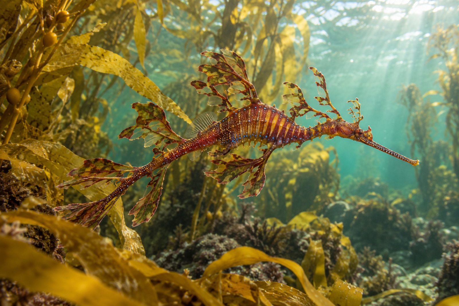
- Weedy seadragons drift through the kelp edges at Flinders and Rye piers — the southern counterpart to Sydney's Kurnell sites — and the piers themselves are festooned gardens of sponges, sea tulips and ascidians that make even a lunchtime snorkel worthwhile. See our weedy seadragon profile for their remarkable biology.
- Burrunan dolphins (Tursiops australis) — a species formally described only in 2011 and found almost entirely in Victorian waters — hold one of their two known small resident populations here, working the fish schools around the Yarra mouth and the eastern shore. There may be fewer than a hundred of them, making Port Phillip effectively their world.
- Australian fur seals haul out on Chinaman's Hat, a platform built in the south channel, and joyride the boats around Mud Islands.
- Giant spider crabs aggregate in winter at Blairgowrie and Rye to moult in their thousands — one of Australia's great animal spectacles in five metres of green water off a suburban pier, and still not fully explained by science.
Add the short-tailed shearwaters overhead in summer, the gannets diving beyond the Heads, rays and smooth stingrays in the shallows, and the resident Port Phillip pipefish on the seagrass, and the bay begins to look less like an urban backwater and more like a nature reserve someone built a city around.
The pressures: a working bay
No honest guide can pretend Port Phillip is pristine. Its catchment drains nearly all of metropolitan Melbourne, and the Yarra still brings pulses of sediment, nutrients and stormwater pollution down to the northern shores. The 2008–09 channel-deepening program that dredged the Heads reshaped some of the outer habitat and remains a cautionary entry in the bay's environmental records. Recreational fishing pressure is heavy; scallop dredging damaged the seafloor for decades before it was stopped in 1997, and the scars are still visible on sidescan sonar.
The response has been substantial, if never quite sufficient. The Port Phillip Heads Marine National Park, gazetted in 2002, protects six key areas at the gateway, including the classic dives of Pope's Eye and the Lonsdale ledges. Catchment treatment has improved dramatically since the 1990s, and the seagrass beds in the southern bay are mostly healthy. The bay is a test case of the proposition that a big city can learn to live with a big reef.
Getting in the water
The bay is one of Australia's great accessible seas:
- Shore snorkelling: Rickett's Point (Black Rock) is the classic beginner's reef — shallow, sheltered, crowded with zebra fish. Flinders Pier and Rye Pier on the southern Mornington Peninsula put you over weedy seadragon habitat in a few metres of water.
- Scuba: the boat dives at the Heads (operated on slack tides, by charter) are spectacular — walls, seawhips and kelp; on slack only. Our shore diving and cold-water diving guides cover the kit and the mindset.
- Kayak and sail: the protected northern bay in summer is Melbourne's own Mediterranean, with kelp-fringed reef reachable from any kayak launch from Beaumaris to Williamstown.
- Timing: autumn is calmest and clearest; winter brings the spider crab aggregations and visibility surprises between storms; summer puts the crowds and the dolphins on the water.
- Piers: Melbourne's piers are full marine habitats — photograph, don't take. Most piers inside the sanctuary areas are no-take; check current maps before you fish.
Key takeaways
- Port Phillip Bay is a 1,930 km² drowned river valley opened to Bass Strait through one narrow, tide-torn entrance — The Rip.
- Sunlight reaches most of its shallow floor, supporting golden kelp meadows, crayweed near the Heads and vast seagrass beds.
- The bay is home to weedy seadragons at the piers, a resident population of recently described Burrunan dolphins, and the famous winter spider crab aggregations.
- The Port Phillip Heads Marine National Park (2002) protects the richest habitat, but the bay carries the full burden of Melbourne's catchment.
- It is among the most accessible temperate reefs in Australia — shore reefs, pier snorkels and boat dives within an hour of the CBD.
FAQ
Why is the entrance called The Rip?
Because of what it does: tidal flow funnelling through the 2.8-km gap between Point Nepean and Point Lonsdale accelerates to several knots over broken reef, throwing standing waves and upwellings that make it one of the most dangerous shipping entrances in Australia. Commercial vessels transit on licensed pilots at carefully chosen tides.
Is there really kelp inside the bay, or only at the Heads?
Golden kelp grows on rocky reef across the southern half of the bay wherever light and hard bottom meet — not just at the Heads — with crayweed on the exposed outer ledges. The northern bay, muddier and fresher, is dominated by seagrass and sediment habitats.
Can you see weedy seadragons without scuba?
Often, yes. Flinders Pier and Rye Pier on the Mornington Peninsula hold seadragons in depths a confident snorkeller can manage, particularly in the cooler months when they move into shallow water. Move slowly near the kelp edges and let them come to you — and read our wildlife ethics in the kelp guide first.
What are the spider crab aggregations?
Each winter, tens of thousands of giant spider crabs gather in the shallows at Blairgowrie and Rye to synchronise their moult — a mass behaviour filmed worldwide but still not fully understood by scientists. Snorkellers can watch from the surface in about five metres of water.
Is it safe to swim off Melbourne's beaches?
The bay is protected from ocean swell, and the swimming beaches are family-grade; the usual cold-water cautions apply year-round (the bay never gets genuinely warm). The real ocean facing the city is Bass Strait outside the Heads — a very different, serious body of water.