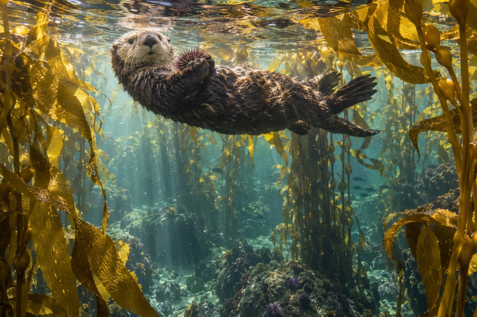
Between Vancouver Island's northern tip and Alaska's panhandle, British Columbia's coastline stops being a coast and becomes a maze: tens of thousands of islands, channels and fjords, most of them roadless, most of them forested wall-to-water in cedar and spruce, most of them known to very few. At the centre of that maze is the Central Coast — the waterways around Calvert Island, Hunter Island, Hecate Strait's southern rim and the Goose Island group — and running through it, Hakai Passage: a broad, current-pulled channel where ocean swells meet the inside-passage labyrinth. It is one of the great living kelp coasts of the North Pacific, and unlike almost any other great kelp coast, it is getting wilder as we watch it. For its neighbours, see our guides to Vancouver Island's west coast and Haida Gwaii.
The place: an inside coast with outside water
Geographically, Hakai Passage lies on the east side of the Goose Island group, several hours by boat northwest of Port Hardy, between the open Pacific swells that slip up Fitz Hugh Sound and the sheltered archipelago water of the inner channels. Water around Calvert Island and the passage is heavily influenced by the outside ocean — colder, more saline, and more nutrient-rich than an inland-sea coast would suggest — while the islands' rims and channels deliver the broken rocky shorelines and current-swept reefs that kelp wants. Water temperatures run roughly 4–8°C in winter and 9–14°C in summer, with the inside passages warming a degree or two beyond the outer islands on hot, still weeks.
This is remote Canada by any standard. There is no road to the passage and never will be; a floatplane from Port Hardy, a water taxi from Bella Bella, or one's own boat are the only doors. Most of the landscape around Calvert and its neighbours is protected under the Hakai Lúxvbálís Conservancy — a provincial protected area co-managed with the Heiltsuk and Wuikinuxv Nations — and Calvert Island hosts an independent ecological field station that has turned this coast into one of British Columbia's most intensively studied nearshore ecosystems.
The kelp: two canopies, one coast
The Central Coast runs the North Pacific's double-canopy system almost perfectly.
In the more sheltered channels — the lee shores of Calvert and Hunter islands, the protected coves within Hakai Passage — Macrocystis pyrifera, giant kelp forms perennial surface canopies over deeper reefs, the yellow-green fronds parting in wind-ruffing patches over towers of rock below. On exposed points and reefs where swell comes straight in off the Goose Island gap, the coast flips to Nereocystis luetkeana, bull kelp: annual, fast-grown, its blades streaming from a single floating bulb at the surface, dying back or storm-stripping each winter and recolonising in spring. Below and between the two canopy systems, the understory is a classic cold-Pacific reckoning: sugar kelp, wing kelp, acid kelp and sea cabbage, and in the surge around low-tide rock, sea palm doing its intertidal survivorship act.
The zonation — surge sea palm belt, bull-kelp fringe, giant-kelp deep canopy — is as clear and visible from a small boat as anywhere in our guide to subtidal zonation, and the visual shift from drying to wet, from winter-stripped to summer-canopied, is one of the great seasonal dramas of diving in this region.
The return of the otters
British Columbia's Central Coast carries the North Pacific's flagship ecological-return story. Sea otters were hunted to functional extinction in British Columbia by the early twentieth century; in 1969–72, 89 animals were flown down and reintroduced to Checleset Bay on Vancouver Island's northwest coast. From that seed, the population has spread north and south at kelp-bed pace, and otters are now established across the Central Coast, including Calvert Island and the passage, with animals rafting in channels they have not used for two centuries.
Where the otters land, the reef reorganises through the classic cascade — our explainer on trophic cascades in kelp forests walks the mechanism — with urchins suppressed to rock crevices, kelp thickening toward the old structure, and fish and invertebrate life redistributing accordingly. On this coast it also produces a deepening cultural and governance story: Heiltsuk, Wuikinuxv, Kitasoo/Xai'xais and other Nations are managing their territories into otter recovery in real time, balancing urchin- and shellfish-foreshore economies against the forest the otters revive — the most live, interesting kelp-management conversation in Canada.
Herring: the spring flashpoint
If you can only pick one season to understand this coast, pick late winter, when the Pacific herring come in. Each February–April, herring in their tens of thousands of tonnes spawn along the Central Coast's kelp and eelgrass edges, laying latticeworks of sticky eggs on kelp blades, rockweed and the hemlock boughs that First Nations fishers still deploy as traditional spawn-on-kelp sets. The spawn turns the water white-blue for miles and detonates a biomass event — sea lions, humpbacks, eagles, wolves, gulls and every human predator the coast holds converging on the same few kilometres of water.
The herring story on the Central Coast is another of the region's defining conservation conversations, tightly bound to Heiltsuk sovereignty and to the federal herring-management debate that has closed and opened fisheries over the decades. Any boat-based visitor to the passage in spring is watching not just a natural spectacle but a live political and cultural one — herring here are people-food and Nation-food first, and the kelp is the stage they come ashore on.
Deep time on Calvert Island
Almost uniquely among kelp coasts worldwide, Calvert Island carries physical evidence of exactly how old people are on this shore: human footprints pressed into paleosol on neighbouring Triquet Island and dated to roughly 13,000 years ago — among the oldest footprints in North America — along with an archaeological record of seasonal villages and clam-garden management running back beyond the datable. The Central Coast today is the continuously-held territory of the Heiltsuk (centred on Bella Bella) and Wuikinuxv (centred on Rivers Inlet) Nations, whose stewardship shaped and survived the seascape for millennia; any guide that treats Hakai as wilderness unpeopled is leaving the story's human keystone out.
Getting there and getting in the water
There is no casual access. The door to Hakai is a floatplane from Port Hardy or a boat from Bella Bella, with Bella Bella reached by air from Vancouver. Visitors who make it typically arrive by:
- Self-skippered or chartered boat, working north through the Inside Passage or down Fitz Hugh Sound — the traditional method, and the one that delivers the full geographic sense of the place.
- A lodge base on the Central Coast — a handful of remote fishing and eco lodges operate within a run of the passage, with guides, small-boat days and increasingly dive-ready services.
- An expedition-style vessel along the Central Coast, several operators running spring and summer itineraries past the passage between Vancouver Island and the Great Bear Rainforest.
Diving here is high-grade cold-water work: drysuit country, currents that demand slack-tide planning, summer water 9–13°C, and visibility that swings from 3 metres in June plankton bloom to 15+ metres in winter's clear, cold dark. Snorkeling in 8–10°C is wetsuit-possible in the best months with the right kit — our cold-water essentials guide applies in full. Accord to the local operators' advice; nobody who has ventured into these waters casually has left recommending casualness.
What's at stake, and what's next
The Central Coast's kelp enters the 2020s in an enviable but uneven position. Old-growth kelp structure has been returning alongside the otters in many channels; the herring stock is one of the healthier on the BC coast; the Nations-led governance model is increasingly shaped by long, continuous tenure on place. The headwinds are the Pacific's own: the mid-decade marine heatwave years hit the Central Coast, with sea-star wasting removing the sunflower-star trophic control on urchins from 2013 onward, and the outer-coast kelp beds cycling through bad-el-niño years like everywhere else. The region's conserved status, its resident science presence, and its Indigenous co-governance bench make it one of the best-positioned coasts on the continent to detect, read and respond to change.
Key takeaways
- Hakai Passage and the Central Coast are a wilderness kelp seascape by Canadian standards: double-canopy giant-kelp/bull-kelp reef across a roadless island archipelago, some of it under conservancy co-managed with First Nations.
- Sea otters, reintroduced to BC in 1969–72, have returned to the passage, re-enabling the otter-urchin-kelp cascade and opening a live governance conversation with the Nations who steward the coast.
- The spring herring spawn is the region's biological and cultural flashpoint, with traditional spawn-on-kelp harvest practice among the coast's oldest unbroken relationships.
- Human presence is ancient: ~13,000-year-old footprints at the edge of the islands; Heiltsuk and Wuikinuxv stewardship is not history, it is current management.
- Access is floatplane or boat from Bella Bella/Port Hardy; diving is drysuit-and-currents work, with best visibility in the cold, clear dark months.
- The coast is one of North America's best-positioned kelp strongholds: wild, co-governed, closely studied, and rising to meet its own sea-star-wasting and heatwave-era questions.
FAQ
Can you dive Hakai Passage?
Experienced divers can, via a lodge or charter equipped for remote BC — drysuit mandatory, slack-current planning essential, and no shore-support or local rescue beyond your vessel's. Non-divers are better served by small-boat touring during herring spawn or summer, when the kelp, seals and sea lions are on full display from the surface.
Where exactly is Hakai Passage?
On the Central Coast of British Columbia, between the Goose Island group and Calvert Island to the west and the mainland fjords to the east — a boat-day northwest of Port Hardy, Vancouver Island. The nearest towns are Bella Bella and, further, Bella Coola; the area sits within co-managed conservancy lands.
Is Hakai Passage part of a protected area?
Yes — much of the Calvert and Hunter Island region is protected under the Hakai Lúxvbálís Conservancy, co-managed by BC Parks with the Heiltsuk and Wuikinuxv Nations. Marine protection around the Central Coast is a layered mix of conservancy, Parks and First Nations stewardship designations.
Why did sea otters come back to the Central Coast?
They were reintroduced to BC waters at Checleset Bay, on Vancouver Island's northwest coast, in 1969–72 after fur-trade-era extirpation, and the growing population has steadily colonised suitable kelp reef north and south from there. Recovery remains partial and patchy — which is part of why the Central Coast management conversation is so active.
What's the best time to visit?
It depends on the intent. For diving and underwater clarity: October to March, cold, clear and dark. For the herring spawn: late February to April. For weather, light and general touring: July to September — with the trade-off of plankton-green summer visibility underwater and peak boating traffic above it.